The LUE Map: What the Hell Is This Thing?
This is the first part of a probable multi-part series on the LUE map. I am in no way an expert on this subject, but I’m interested. I’ve read a thing or two about it, and I find that when I write, I learn. And so, in an attempt to learn more about this crazy treasure map, I’m going to write. Maybe we will discover something new along the way. Maybe we’ll find Karl’s parking lot treasure, or possibly the wizard behind the curtain. Let’s find out.
If you've spent any time thinking about treasure hunting, you've probably heard of the LUE. If not, then you are like I was a couple years ago when I saw this, I don’t even know what to call it, this map? I surely saw it for the first time in Treasure Hunter Manual 7, written by Karl Mueller, but I’m positive at the time I just glossed over it. I probably saw the map, read the caption, decided this is not for me, and moved on to the more practical treasure hunting tips and tricks in that book. Then I met Randy Bradford, the LUE expert, at a treasure hunter gathering in Utah and I found him to be a gem of a man, and well, I’ve picked up an interest in the LUE now.
So what is this thing? The LUE , apparently, is a treasure map, or at least that's what we're told. It is also the name used for the treasure site(s) itself, so you'll hear the word used both ways depending on who's talking. For my purposes, when I say "the LUE," I'm talking about the map and I’ll clarify otherwise if I need to.
It doesn't look like any map I’ve ever seen before. There are no place names. There is no compass rose. No distances are marked, and there’s no dotted trail leading to an X. What we see instead is a precisely drawn collection of geometric shapes, lines, curves, and symbols. When I say precisely drawn, I mean precisely. It looks like every line or arc on this “map” was drawn with either a square or straight edge, and a compass. In the upper left quadrant there is what appears to be the bottom half of the sun, shining eleven rays of light down into the scene at various angles. Also in the same quadrant is a right triangle with stair steps laid upon the hypotenuse, and a pyramid with three sections inside. There are vertical and horizontal pillars, one of each, each of which dissects the map down its respective center. An all-seeing eye stares out from the upper right quadrant. There are also various other lines in this quadrant that probably mean something, and there is the top half of an arrow-head thing which serves as the tip of the horizontal pillar. So, then maybe it’s not a pillar. Later…moving on. The lower right quadrant shows the bottom half of the tip of the horizontal pillar, and a strange looking series of triangles inside triangles. It’s very geometric. There is a circumpunct, and a horizontal line cuts across the upper portion of the quadrant. On this line is a small inverted triangle, pointing down. The lower left quadrant of the map looks like a wall of bricks, the type a stonemason would lay out as the side of a house for example. On top of all that and over the entire map, there appears to be two sine waves of varying amplitudes.
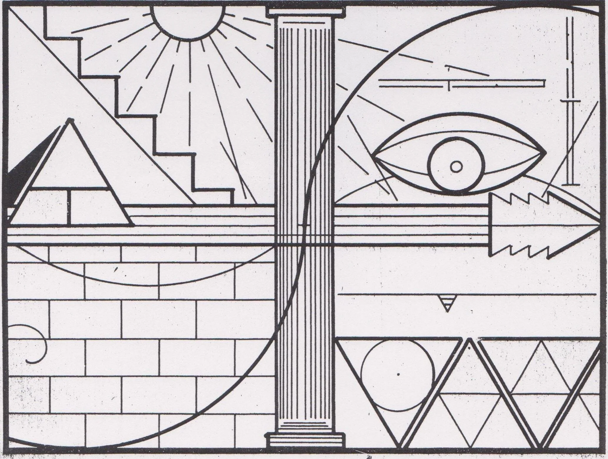
The LUE map.
We get this design by way of a man named Karl von Mueller.
Karl von Mueller is one of those unavoidable and ubiquitous names you find in the treasure hunting world. He was a prolific writer who published dozens of well-respected and loved books on treasure hunting and cache hunting. He edited and contributed to multiple newsletters and magazines simultaneously, sometimes under his real name Charles Dean Miller, and sometimes under pen names like Deek Gladson, or Karl. In Segundo, Colorado, he ran a gathering place called the Exanimo Establishment, where he sold books, serviced metal detectors, and maintained a research library. He seems to have slept about two hours a night and spent the rest of his time writing. When you look at the sheer volume of material that he produced, it borders on unbelievable.
As I said earlier, Karl published the LUE map in 1966 in his Treasure Hunter's Manual Number 7. He dropped it into the middle of the book with a caption underneath. That was it. That caption reads:
"The LUE Map which will perplex treasure hunters for years to come. Only two people have been able to decipher it and they will never be able to carry away all of the incredible treasures that are revealed by the map. Others will seek, and few will find; and the trovers will be committed to eternal secrecy when they learn the cryptic and shibboleth horde of all hoards on the American continent. True sign experts will find the ultimate in challenges in this key to a natural Fort Knox. Redrawn exactly from the IAYAYAM Key."
What is a "shibboleth horde"? Why use that word in a publication aimed at hobbyist treasure hunters? What is the IAYAYAM Key? Karl never explained it. Some researchers have since proposed that IAYAYAM stands for "I Am Yours and You Are Mine," derived from the first letter of each word. What that phrase means in the context of the map remains an open question. I haven’t heard of anybody being able to meaningfully apply that phrase to the map as a “key.”
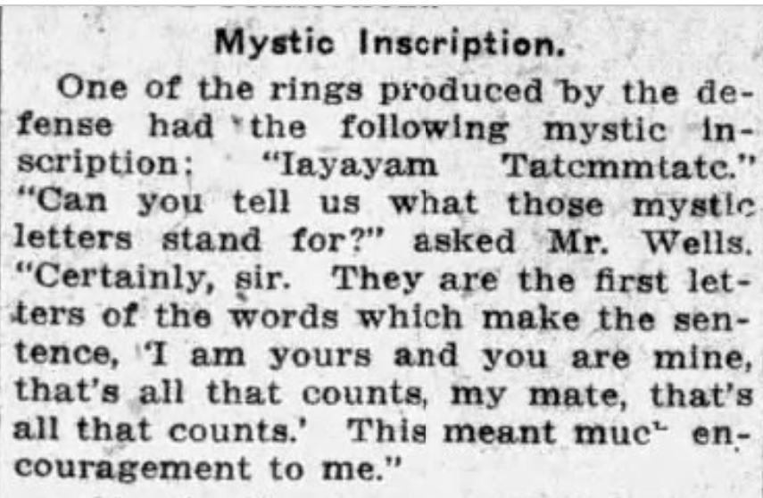
A strange reference to IAYAYAM. The Republican, June 5, 1914
The map itself did not originate with Karl. Only this version, the publicized one, did. Karl received it from a man named Bill "Hardrock" Hammond, a friend and mentor of Karl’s. Hammond had obtained it from someone living in or near Phoenix, Arizona. The map had reportedly been in that family, the Phoenix family, for years and had been seen by dozens of people before 1960, allegedly. Karl and Hammond copied it, returned the original, and from there it entered the published record. The original has never surfaced.
Most of the information we have about the LUE comes directly from Karl von Mueller. That is a real vulnerability from a research standpoint, obviously, because it means the entire foundation of this story rests on one man's word, Karl’s, a man who used multiple names. Randy Bradford, who has done more work on the LUE than arguably anyone alive, puts it like this: the strength of the map rests on Karl von Mueller's reputation. People who knew Karl consistently spoke highly of him and seemed to honestly believe in his integrity. The single-source problem is real, though, and it is what it is.
Karl claimed that he personally made a recovery on the LUE, sometime in the mid-to-late 50’s, potentially close to a decade before he ever published the map. His partner at the time was the above-mentioned Hardrock Hammond. When Karl wrote that "only two people have been able to decipher it," he was almost certainly referring to himself and Hardrock. The story goes that Karl hauled at least one pickup truck full of gold out of the site and left far more behind because he simply could not carry it all. His attitude, as he expressed it in print, was essentially that the gold was there for anyone willing to go get it, and that he already had all he needed.
The recovery sites that have been reported over the years cluster in northern New Mexico and southern Colorado. Places like Black Lake, Elizabethtown, Mora, and Romeroville appear repeatedly when you read about the supposed sites associated with the LUE map. Most of these places are ghost towns now, which seems to align with a comment Karl made one time, remarking that "no existing town or city has any relationship to the LUE except by coincidence." That word "existing" is doing a lot of work in that sentence ,and it could mean that certain ghost towns do have a relationship with the LUE.
Karl also emphasized the importance of a specific geographic feature: the 105th degree, 12 and a half minute longitudinal parallel. That line runs through both Colorado and New Mexico, and the reported recovery sites cluster close to it. Whether this parallel is encoded in the map or simply describes the general region where the caches were located is another question nobody has definitively answered, publicly, or maybe they have and I haven’t seen it yet. We’ll get there, eventually.
There are competing theories about where the treasure came from. Karl said it was "probably hidden by the Padres," and he connected it to stories of Spanish and Jesuit mining operations in the region. Others have proposed connections to the Knights of the Golden Circle, the Confederate-affiliated organization that allegedly cached gold and supplies across the country during and after the Civil War. Some researchers have pointed to French miners. A few have even floated a Nazi connection.
What nobody disputes is that the map is loaded with symbolism. I would like to say some of it looks Masonic. To my eyes though, a Mason, I can see Masonic symbolism in the entire thing. From the all-seeing-eye, to the the bricks, the stair-steps, the pillar(s), the blazing star, the triangles, the pyramids, and absolutely the circumpunct, a circle with a dot in the center, which is the mark made when someone uses a compass to make a perfect circle or arc. Some of it has been interpreted as navigational and I can see where they are coming from. It seems like a valid interpretation to me. Some of it looks mathematical in nature. Making sense of how these layers relate to one another, is the central challenge of the LUE and well, I’m at least going to write about it, if not try to solve it.
Next time we’ll dig another hole and jump in. I hope you come along for the ride.
Until then, happy trails.
A big thank you to Randy Bradford for reviewing this piece and keeping the facts straight.
If you want to get ahead of the curve, I would recommend picking up Randy Bradford's book, The Lue: Map, Treasure and Mystery. It is the most thorough examination of the LUE in print. Get it here!
If you would like to wear this strange LUE map proudly on your chest like a true expert of all things treasure hunting and the arcane, we have that covered too right here!
For a much more thorough breakdown, watch Randy's interview with Terry Carter below!
Stay in the loop. Sign up for the Buried Expectations newsletter!
This research takes time. If it added something to your day, you can buy me a coffee. Thank you!